


Géomètres Blue Hills, LLC
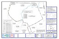
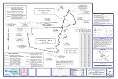
This project was a joint project between Geometres Blue Hills, and York Land Services, out of
Berlin, NH. We used a combination of conventional survey techniques and GPS surveying
equipment to complete these boundary plats for the federal government. The National
Resources Conservations Service offers various easement programs to landowners who want
to maintain or enhance their land in a way beneficial to agriculture and/or the environment.
The Wetlands Reserve Program (WRP) protects, restores, and enhances wetlands. Achieving
the greatest wetland functions and optimum wildlife habitat on every acre enrolled in WRP is
the goal.
Cheney Property
Kelley Property
Copyright 2013 Geometres Blue Hills, LLC - 240 Hornetown Road, Farmington, NH 03835